What is the CSS LiDAR Map Server? |
||
| It is the publicly viewable, Centre for Samoan Studies/National University of Samoa (CSS/NUS), collection of LiDAR and aerial photos of the Independent State of Samoa (Upolu, Manona, Apolima, Savaii). |
| • |
LiDAR stands for Light Detection And Ranging. Please see An Introduction to LiDAR for a brief (14 page - mostly pictures) explanation of LiDAR. |
 |
||
| • |
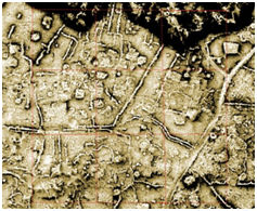
LiDAR allows us to see “around/through” vegetation seeing the “hidden” archaeological features beneath (see example on the right). A more indepth explanation and examples are given on the LiDAR Info page of this web site (also see the menu above). |
|||
| • |
This web page has been made possible through the generous assistance of and our collaborative efforts with the Samoan Ministry for Natural Resources and the Environment (MNRE) who furnished the raw LiDAR data and aerial photos for this page. | |||
|
||
| The Map Server is an effort to make Samoa’s Hidden Cultural Heritage available for everyone to see, scholars and the public alike. | ||
| It is hoped that allowing everyone to view the extent of this previously underreported cultural treasure will build interest in Samoa’s cultural heritage and encourage the Samoan Government to pass meaningful cultural heritage protective legislation (which does not presently exist and is badly needed). | ||
|
||
|
A new section - Samoan Armchair Archaeologist - has been add to the CSS LiDAR Map Server web page that allows the public (scholars and lay persons alike) to assist in recording Samoa's Ancient Cultural Heritage. If you are interested in helping CSS/NUS in better understanding this underreported intellectual treasure now displayed through the CSS LiDAR Map Server please see the Samoan Armchair Archaeologist link in the menu above. |
||
|
||
| The maps and diagrams displalyed on the Map Server Main Map pages and the SAA Main Map pages can be displayed in QGIS (a free GIS software package) in Web Map Service Layers (WMS format) by following these steps (pdf). | ||
|
(Also available through the menu above.) |
||
Comments and/or suggestions can be sent to: g.jackmond@nus.edu.ws
LiDAR curtesy of MNRE
(C) 2018 Centre for Samoan Studies, National University of Samoa. All Rights Reserved.

