|
|
Samoa has a rich
and diverse archaeological and
cultural history spanning some 3000 years. This history represents all
major
phases of human activity in the southern pacific region commencing with
the
arrival of the Lapita peoples, the region’s first human colonists.
Samoan oral
traditions encompass a deep account of the past. There are many kinds
of oral
traditions; proverbs, genealogies, village histories and protocol
statements
(fa’alupega), myths and legends, fairy tales, songs, and poems. Some
refer to events
over the past 5-600 years (using genealogical reckoning), or to
mythological
eras when the islands were created by the ancient gods. Others recall
major
events of more recent times. A large body of oral tradition was
recorded in
writing in the 19th century by missionary scholars (for example Pratt
1890, Ella,
1895, Stair, 1896, Fraser 1896) and by anthropologists, notably Kramer
(1994
[1902]) and Buck (1930). Since 1903 The Samoa Land and Titles Court has
stored
written records in the Samoan language of family and village histories.
Today
most families also have written versions of significant family oral
traditions. However, many oral traditions continue to reside in the
memories of
older Samoan people and are passed down in families and villages in the
traditional manner, although this mode of transmission is under
increasing threat
as Samoa modernizes.
There is a need to keep track of the archaeological sites that were
recorded during the early phase of research activity during the 1950s
to 1970s, as well as more recently discovered sites. There is currently
no central database to help conserve and manage Samoa’s rich
archaeological heritage and there is no central government agency
tasked with this responsibility. This represents a significant risk for
the effective conservation and management of Samoa’s archaeological and
cultural
heritage and its associated oral traditions.
Samoa currently possesses no central database of archaeological sites
or historic places and this presents a significant disadvantage for the
protection, conservation, and management of Samoa’s archaeological and
historic heritage. It is the aim of this project to rectify this
situation by compiling a database of Samoa’s known archaeological and
built heritage places and their associated histories and oral
traditions (as applicable) with the purpose of documenting, conserving
and preserving Samoa’s cultural heritage. This will be the first
project of this type to be conducted in Samoa.
Project Update (as of December 2016)
|
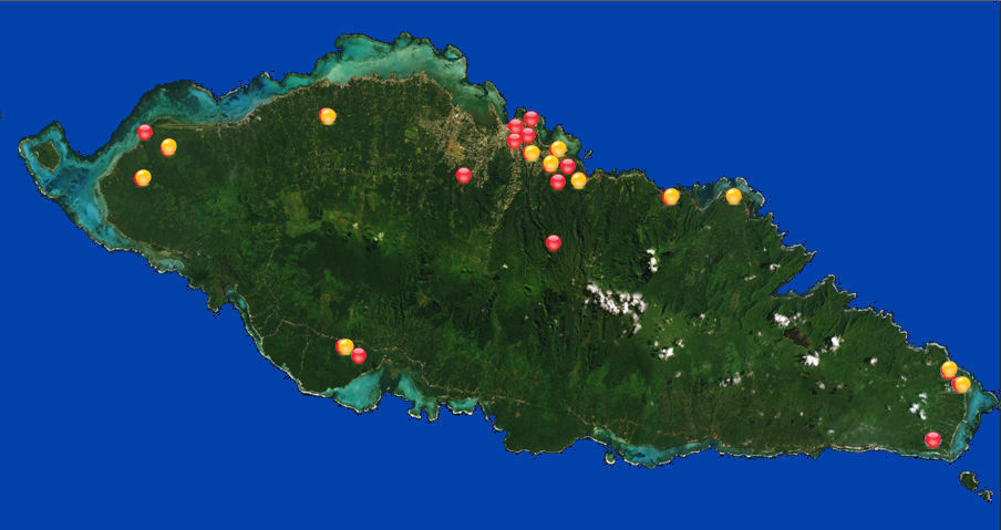
Having completed our first Field Season in June 2016, the AFCP Project
Team are compiling data recorded from 30 sites across the island of
Upolu. SEE OUR GIS MAPS ABOVE - "ACADEMIC REASEARCH" or TAKE OUR "QUICK TOUR".
Our next Field Season is June 2017, this time to the big island of Savai’i.
Watch this space!
|
Project Update (as of October 2018)
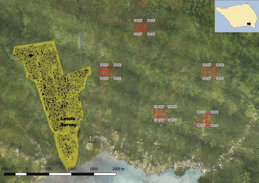
In 2017 CSS conducted two field surveys, one in Palauli, Savaii and the other in Aleipata, Upolu, both providing a wealth of knowledge about Samoan archaeology and cultural heritage:
Palauli, Savaii Survey:
|
In three intensive field school weeks between April and June 2017 CSS surveyed five 300m x 300m sections of Palauli District, Savaii in the inland sections of the villages of Faaala, Vaitoomuli, and Vailoa. Aided by the recently rendered LiDAR maps of Samoa (see: [LiDAR Map Server] link at the top of the page) (LiDAR LAS files courtesy of MNRE) and aerial drone footage (provided by SkyEye Pacific), the CSS team, consisting of staff, students, volunteers, and villagers discovered hundreds of previously undocumented archaeological features (see: [Academic Research - QGIS 3d : Palauli, Savaii 2017 Survey] link at top of page) showing that not only are there extensive inland villages all throughout Samoa, but also that there was a substantially larger pre-contact population than previously suggested (see: “Samoa’s Hidden Past: LiDAR Confirms Inland Settlement and Suggests Larger Populations in Pre-Contact Samoa” in the [Publications and Presentations] link at the top of the page). |
Palauli Heritage Trails, Savaii:
|
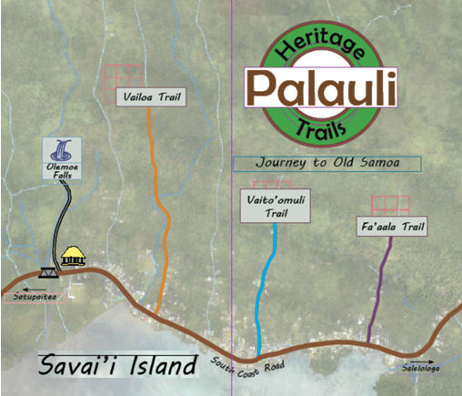
Through the asperses of a two year UNDP-GCF grand obtained in late 2017, CSS, along with its partners in the Samoan Government (STA (Samoan Tourist Authority), MESC (Ministry of Education, Sports and Culture), MNRE (Ministry of Natural Resources and the Environment)) are in the process of helping the villages in Palauli develop the “Palauli Heritage Trails Trust” to aid in establishing cultural heritage tourism sites connected to the discoveries of 2017.
A film crew from Tagata Pasifika visited the Trails in October 2019. View the video [TagaPasifika-SamoasAncientStarMounds].
|
Aleipata, Upolu Survey:
|
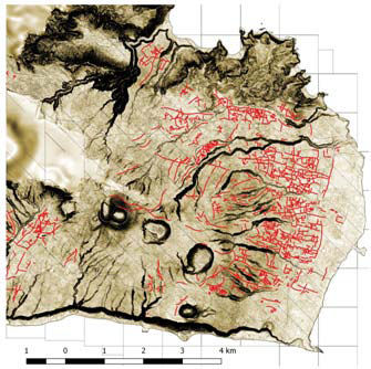
In a six day field season in September of 2017, CSS continued rewriting Samoan history with its field work in the inland sections of the village of Samusu, Upolu. Again, using the recently rendered LiDAR maps of Samoa and drone footage as a guide, this latest phase of the research by CSS has revealed an extensive pre-19th century systems of agricultural land modification in Aleipata district; a network of over 150 km. of channels covering an area of 20 or more square kilometers encompassing the entire eastern tip of Upolu suggesting that an organized system for constructing and maintaining an extensive network of interconnected channels must have existed at a time prior to the 19th century when Samoan political organization was first recorded. (see: [Academic Research - QGIS 3d : Samusu, Upolu 2017 Survey] link at top of page). This research not only refutes the assertion that Samoa did not have an intensive agricultural system but again shows an extensive pre-contact population.
A report on the survey was published in June 2019 (see: “Did Samoa have intensive agriculture in the past: New findings from LiDAR” in the [Publications and Presentations] link at the top of the page).
|
CSS has also been working on several other projects during 2017 and 2018:
UTU:
|
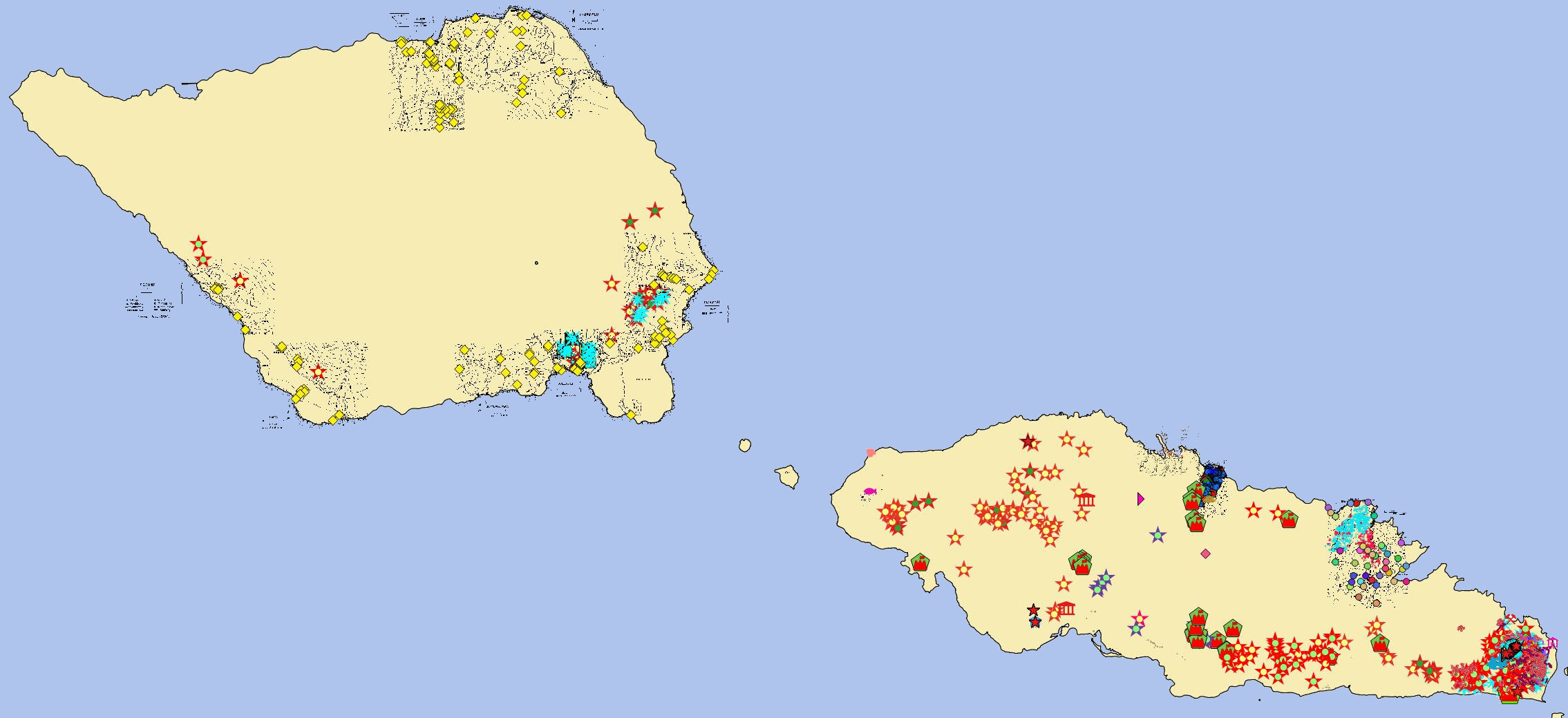
All though out 2017 and 2018 CSS has been constantly adding to “UTU" – “Samoan Archaeology and Cultural Heritage Database for the Independent State of Samoa” that it started in 2016 (see: “UTU" -- Samoan Archaeology and Cultural Heritage Database for the Independent State of Samoa” in the [Publications and Presentations] link at the top of the page). There is currently over half a terabyte of data in the QGIS system and the amount is growing rapidly as more original CSS research is done and past materials are added to the system. Despite the fact that CSS has been working on UTU for over two years now, it is far from complete, and in reality will probably never be completed, but always be a work in progress. As time and technology allows CSS hopes to make much of the information in UTU available to the public just as it has made the archaeological LiDAR for Samoa available (see: [LiDAR Map Server] link at the top of the page).
|
CSS LiDAR Map Server:
|
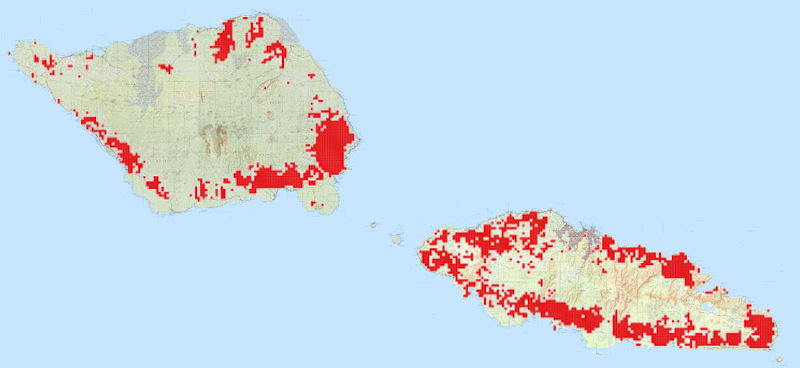
The map server has been a work in progress since February 2017 when the first LiDAR files provided by MNRE were rendered into viewable images. The web page and data were completed in mid 2018 and have been awaiting the hardware necessary to put it online. Finally in early October of 2018 the computer equipment need to set up the LiDAR Map Server was procured. The result is “The CSS LiDAR Map Server” (see: [LiDAR Map Server] link at the top of the page). It is the publicly viewable, Centre for Samoan Studies/National University of Samoa (CSS/NUS), collection of LiDAR and aerial photos of the Independent State of Samoa (Upolu, Manona, Apolima, Savaii). The Map Server is an effort to make Samoa’s Hidden Cultural Heritage available for everyone to see, scholars and the public alike. It is hoped that allowing everyone to view the extent of this previously underreported cultural treasure will build interest in Samoa’s cultural heritage and encourage the Samoan Government to pass meaningful cultural heritage protective legislation (which does not presently exist and is badly needed).
|
Apia Village, Upolu Survey:
|
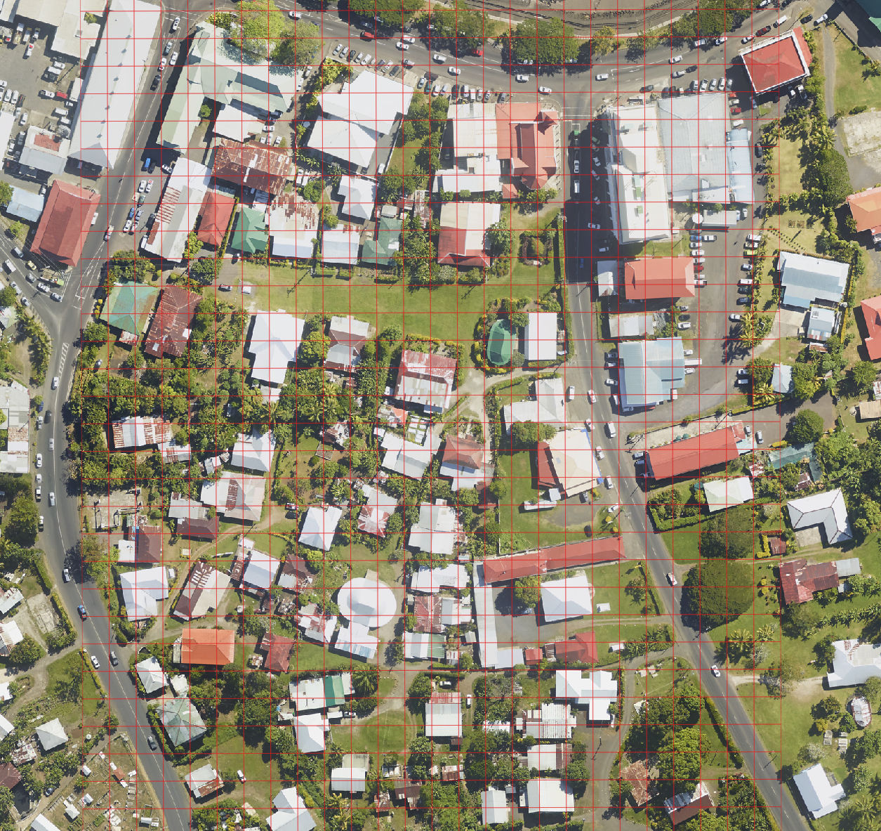
The purpose of this project is to generate a basic chronology of human habitation in the village of Apia before European settlement. The field site is focused around the Apia malae as the traditional epicenter of Samoan village life, and should therefore provide the most evidence of human activity, particularly by Samoans. We aim to develop a baseline for a deeper understanding of the pre-contact history of Apia, therefore requiring a mixed archaeological and ethnographic approach. The CSS research team plans to collect ethnographic information about the village through a survey of Apia Village households, and take and analyze core samples from selected areas within the village of Apia. The basic household survey, and preliminary coring will start in October 2018 with the extensive geological coring taking place in March of 2019. This project has been funded by a UREC (University Research & Ethics Committee) grant from NUS.
|
|
|
|
